Stir-crazy yet? After nearly three months of social distancing, that’s to be expected. And yet, things aren’t exactly back to normal. Never fear, we’re here to help with five great day trips from Kansas City that are all outside. We picked spots that are safely spacious but which offer excitement, fresh air and much-needed changes of scenery. Get out there, but remember to use common sense and follow CDC guidelines.
TRAVEL NECESSITIES
Things are still a little crazy out there right now—you may find that public facilities you’d expect to rely on in places like parks are closed or unsafe. Be self-reliant by bringing essentials with you.
- Bottled water
- Toilet paper and trowel
- Hand sanitizer or soap, extra water and paper towels
- Masks
- Gloves
- Granola bars or other snacks
- Bug repellent
- Sunscreen
The best hiking in the KC area is up in Weston
To stand on a rocky Missouri bluff while experiencing breathtaking views of rolling green hills, you need to take the quick trip up to Weston.
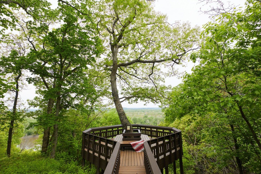
Weston Bend State Park has a few walking trails, but West Ridge Trail is the best: A large portion of the trail abuts the Missouri River and gives hikers sweeping views of the flowing water and the other side of the state line. West Ridge’s two-and-a-half-mile loop is moderately difficult with a few steep elevation changes, but the trail itself is pretty smooth. Still, it’s smart to be on the lookout for exposed roots, rocks and mini mudslides after a rainfall.
West Ridge easily connects to Harpst Trail and Paved Bicycle Loop. If you take the long loop through all three trails, it’ll take you about two-and-a-half hours. There’s a lookout point a few feet from the West Ridge Trailhead—we recommend saving this for the end of your hike as a reward for your efforts. The scenic overlook, a planked deck tapered around a tree, gives panoramic views of the state line river and Fort Leavenworth’s imperial-looking clocktower. —Nicole Bradley
GO: From I-29 north, take the Tracy exit to 273 west and follow signs for Weston Bend State Park. Follow the park road to the last parking lot, where you will find the trailhead.
While you’re there: Visit O’Malley’s Pub. The historic bar sits six stories below the limestone bones of the old Weston Brewing company, which dates back to the mid-1800s.
An abandoned town is as cool as it is creepy
Type “Dunlap, Kansas” into Google Maps, and there sits a small square around an unincorporated town on the eastern edge of the Flint Hills.
Dunlap was once a town for Exodusters—freed slaves fleeing to Kansas—during the Reconstruction Era that followed the Civil War. Exoduster Benjamin “Pap” Singleton migrated to Dunlap from Tennessee and started a colony there in 1880. Life for the Exodusters wasn’t easy. They were forced to segregate and treated poorly by white settlers. There was even a separate cemetery for Exodusters.
The population of Dunlap dwindled around the time of the Great Depression, and the town filed for bankruptcy. In 1988, Dunlap’s post office shut its doors, and in 1993, Dunlap’s last black resident was buried in the colored cemetery. Not much is there today. A few deserted homes and an abandoned high school gymnasium still stand despite the school being demolished over a decade ago. One poignant reminder of the town’s history is the Colored Cemetery. The Dunlap City Cemetery sits right on the edge of town while the Colored Cemetery, which was inducted into the National Register of Historic Places in 2018, is about a half mile out in the rolling Kansas hills. —Nicole Bradley
GO: Take I-70 to Topeka. Hop on I-470 and take the Kansas Turnpike. Take exit 147 toward US-56/Council Grove/Osage City/Admire. Take US-56 until you hit Road F, then take F until Road 290, which will take you into Dunlap.
Ha Ha Tonka is one of the most photogenic spots in the state of Missouri
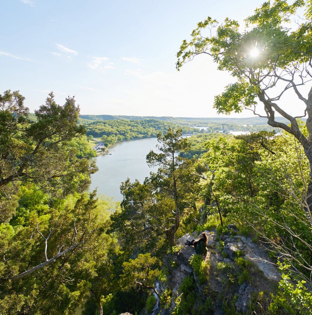
Back in 1903, Kansas City natural gas baron Robert McClure Snyder decided to build an Ozarkian oasis on a bluff above one of the state’s largest natural springs, where cool, pure green waters flow up from the earth.
No expense was spared by Snyder—the visionary owner brought over Scottish stone-masons to employ traditional European techniques with local stone—but after he died in one of the city’s first auto accidents, the unfinished estate suffered a series of setbacks before finally burning to the ground.
Today this popular state park has a network of trails mostly covered by boardwalks, which protect the spring-sodden ground around the emerald-green lagoon of fresh springwater that feeds into the Lake of the Ozarks.
The parking lot near the castle is tiny and overrun, so get there on a loop from the Post Office Shelter trailhead. Follow the blue trail down the hill to the lagoon, take the boardwalk over it, and climb the stairs two-hundred vertical feet to the top of the bluffs. From there, follow the red trail to the other side of the lagoon and the castle ruins overlooking it. Double back on the red trail after exploring the ruins, then stay on top of the ridge and follow the rest of the blue trail loop back to your car. —Martin Cizmar
GO: From I-49 south, take exit 157 for Route 7. Follow Route 7 for 67 miles to Warsaw. Take a right onto US-65 south. Follow US-65 south for 25 miles, then take a left onto US-54 east. Go 25 miles east on US 54 to Missouri D. Take a right on Missouri D and go 2 1/2 miles to the Post Office Shelter parking lot. The trailhead is on the north side of Missouri D.
Northwest Arkansas has some of America’s finest mountain biking
You don’t have to be in Bentonville long to realize that biking isn’t just an afterthought; it’s become integral to the culture of this thriving northwest Arkansas community. The energy and passion from the locals (and the Walton family) have helped grow this town into a biking destination for cyclists of all pursuits and skill levels. Trails here serve as a network of roots, which are all interconnected and lead back to the town as a central hub. The accessibility of these trails, both in location and degrees of difficulty, is impressive.
Bentonville has employed professional trail builders to build miles of trails that are not only enjoyable to ride but easy to work into daily life. You can commute to work by bike without leaving the trails. One of the most unique features of the system is that trails are integrated into the infrastructure, allowing riders to explore all of Bentonville by bike. The Crystal Bridges Museum of American Art is located within pedaling distance from the downtown square and features a bikeable art trail that meanders past sculptures and waterways. Hotels, restaurants and coffee shops are all within riding distance of mountain bike trails. Phat Tire, a full-service bike shop located on the town square, offers everything you need to get your bike on the trails, as well as guided tours, shuttles and bike rentals.
Here’s the lowdown on three trails to get you started. —Kim Horgan
Slaughter Pen is a twenty-plus-mile, moderately trafficked loop of flowy singletrack mountain biking trail that runs past the Crystal Bridges Museum and includes difficulty levels from beginner to expert.
Color Preserve trails are built on land designated as a mountain bike preserve but located only two miles from downtown Bentonville. Coler features miles of flowy, technical, rocky trails with several jump features. It is one of the state’s most challenging enduro-style trails.
Razorback Regional Greenway is a collection of nineteen interconnected bike trails covering thirty-six miles and connecting Bentonville, Fayetteville and their suburbs. It’s entirely off-road or protected bike lanes. The Lake Springdale section is particularly scenic.
GO: Fayetteville is 225 miles south on I-49.
While you’re there: As home to one of the world’s most successful corporations, Bentonville has an embarrassment of cultural riches. None are more impressive than the Crystal Bridges Museum of American Art, home to everything from Gilbert Stuart’s definitive portrait of George Washington to modern icons by Warhol and Rothko. The museum is free.
The most impressive native American ruins north of Mexico

There was a time when St. Louis was the largest city in the country. Well, not St. Louis, exactly, but Cahokia, the Native American settlement on the eastern shore of the Mississippi. Archaeologists believe it was as large as London during the High Middle Ages, around the time William the Conqueror was leading the Norman Conquest of England. Monk’s Mound is the largest Native American mound north of Mexico and one of only two dozen UNESCO World Heritage Sites within the United States. It rises a hundred feet over East St. Louis, offering views of the arch and the city skyline. —Martin Cizmar
GO: Cahokia is 258 miles east of Kansas City. Take I-70 east to exit 6, then go east on Collinsville Road to the mounds.
While you’re there: Once the largest train station in the world, St. Louis’ Union Station is now home to attractions including the new St. Louis Aquarium, a massive aquatic attraction with 13,000 animals including a massive shark exhibit and adorable otters. The aquarium opened last Christmas and has quickly risen to one of the top tourism destinations in STL.